Angel Island. Bodega Head. Old Faithful Geyser. The North Bay is rife with amazing outdoor destinations—some like the Golden Gate Bridge and Muir Woods are so familiar tourists carve out time in their vacation plans to visit such places weeks in advance.
But did you know there’s a ghost town in Sonoma? A Cold War-era missile site in the Marin Headlands? A “cursed” state park in Novato? The North Bay is loaded with many hidden gems—even longtime locals are unaware of some of the coolest finds just minutes away. Here are a few of our favorites:
The Mysterious Unexplained and Not-At-All Satanic Labyrinth at Shell Beach
In the late 1990s, a spiral labyrinth-shaped path was mysteriously hand-cut into the grass between Shell Beach and Goat Rock near Jenner. According to the Santa Rosa Press Democrat, state parks officials initially wondered if the strange occurrence carried cultish or satanic undertones, but ultimately left the unauthorized new trail alone. More than two decades later, it’s morphed into a place of contemplation and spirituality, with travelers leaving stones, shells or personal objects from lost loved ones. At the center of the spiral is a shrine of remnants, encompassing 25 years of hope, grief and longing of its many pilgrims. Look for it in a meadow off the Kortum Trail, north of the Shell Beach parking lot. More info at labyrinthlocator.org.
Only Thing Standing Between You and Nuclear Armageddon: Magical Marin
From 1953 to 1979, the U.S. Army operated nearly 300 Nike missile sites—intended as a last line of defense in the event of a nuclear attack by the Soviets. The site known as SF-88 sits in the Marin Headlands as the most fully restored missile site in the country.

Docent-led tours are offered every Thursday, Friday and Saturday, where you’ll traverse the site, see deactivated missiles and other Cold War equipment and learn the fascinating history of the time and place. The idea was if Soviet aircraft loaded with nuclear bombs made it past our Air Force defense, the crew at SF-88 would be called to shoot them down with the Nike missiles. By that point, the men had 23 minutes to live—duck and cover be damned. More info at nps.gov.
Wine Country OG: Wingo
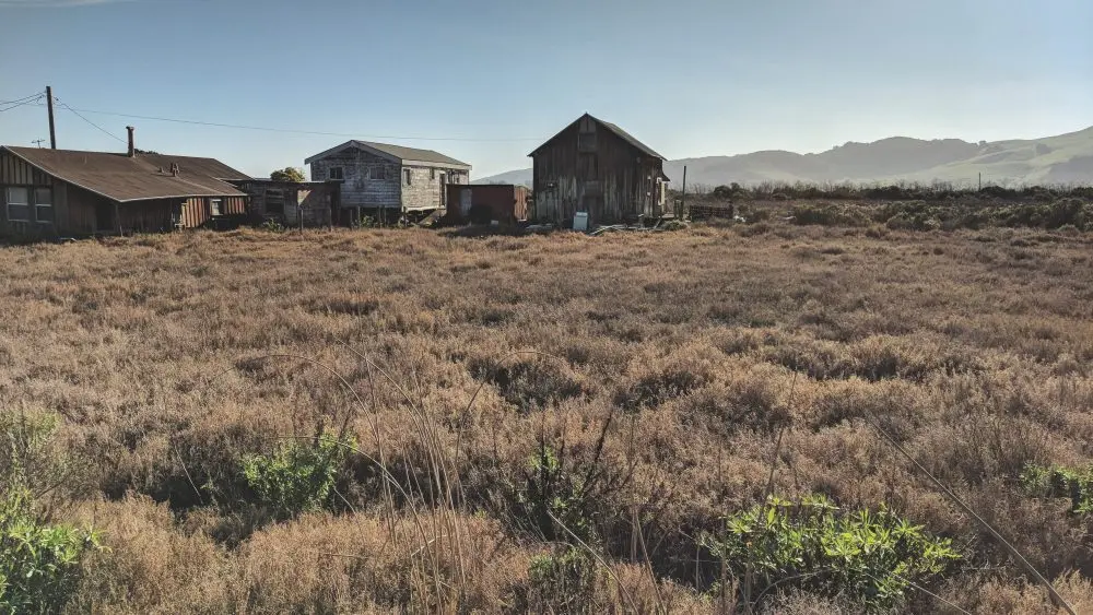
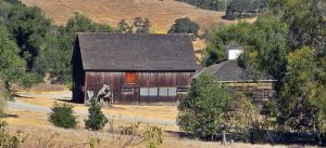
Before today’s multi-million-dollar homes and winery estates littered the Valley of the Moon, there was Wingo—a 19th-century paddle-steamer stop for travelers and supply shipments ferrying up Sonoma Creek. At its peak in the 1840s, the town (originally called Norfolk) bustled with fishermen, duck hunters and, later, San Franciscans making their way to Sonoma and its nearby wellness resorts. By the time the rail company set up tracks (and changed its name to Wingo for unexplained reasons), the town was thriving, at least as much as a mosquito-plagued ferry junction could. The opening of the Golden Gate Bridge, however, was the writing on the wall for Wingo as transportation switched permanently to the roads and residing near a swampy flood-prone creek lost its allure.
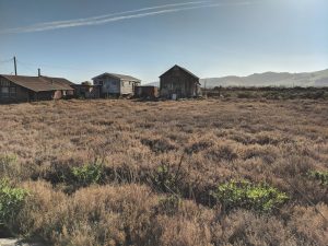
By the 1990s, the “town” claimed only one resident, the elderly widow Alice Mann, who’d bought her cabin in 1956 for cool $1,000, potentially the only real estate purchase in Sonoma County to ever go down in value. Various fires and floods over the years finished Wingo off for good and today what’s left are several dilapidated structures, residents of an adjacent property (with an alleged prickly reception for gawkers), and the eerie aura of a California past never to be seen again. To get there it’s about a 3-mile hike, beginning near Larson Winery off Highway 121; the tides can render it swampy, bring your water boots.
Tubbs Island, the Toilet of the North Bay
Anyone who’s driven east on Highway 37 past Sears Point has gazed at the lush, green marshland to the left and asked themselves the immortal question: Why is there a toilet out there? That wooden outhouse framing the porcelain throne in the middle of the San Pablo Wildlife Refuge—Google maps calls it the “Lone Toilet”—is the last remaining remnant of Tubbs Island, a long-lost town (much like Wingo, see above) whose boom era at the turn of the 20th century was made possible by cordage magnate Hiram Tubbs, who diked the baylands and turned it into a farming community and duck-hunting club. Tubbs Island’s heyday ended when the land came under control of the U.S. military during World War II and various branches used it for everything from gunnery practice to chemical warfare training. Tubbs’ most famous resident was the legendary Richard Janson, a crusty former seaman who lived a hermetic existence on what’s been described as an “ark” and sold hand-carved duck decoys. “Fresh Air Dick,” as he was known, died in 1951. The levies were eventually breached in the 1970s and Tubbs Island sank into the mud like Atlantis. Only the toilet remains to tell the tale.
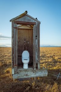
If you want to visit the Lone Toilet you need a rubber raft to get through the marsh. Some pranksters make the journey for the express purpose of actually using the toilet; consider yourself warned.
Native Kitchen Where the Mariposa Lilies Grow
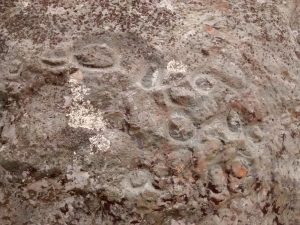
While the Mayacamas and Mt. Tamalpais get all the North Bay geological press, nearby Ring Mountain is nothing to sneeze at—that is, unless you’re allergic to the extremely precious flower that grows on it. Situated on the north side of Tiburon, Ring Mountain is home to the Tiburon mariposa lily, a rarest-of-rare member of the Liliaceae family which blooms in late spring. In fact, TML takes the concept of “rare” to new heights—the only place in the world it’s found is Ring Mountain and grows on a single twisting outcrop of grassland less than a football field in length. The Coastal Miwok of centuries past surely enjoyed the sights of the Tiburon mariposa lily, as those native Americans left an indelible mark on Ring Mountain, in more ways than one. Circular petroglyph carvings—some estimated to be as much as 2,000 years old—are visible on the aptly named Petroglyph Rock, located near the base of the mountain, about a third-of-a-mile up the Phyllis Ellman Trail (named for a local 1970s conservationist who stymied development of the mountain).
About half-a-mile up the Phyllis Ellman Trail there are even rocks with Native American grinding basins carved into the stone. At this so-called “Indian Kitchen,” the basins were used to process acorns and shellfish and were so prolifically used, shell middens are still visible in the area.
Find trailheads at Taylor Road or Reed Ranch Road off of Paradise Road in Tiburon.
Olompali—cursed, or ‘super groovy’?
It’s a stretch to call an officially designated state park a hidden gem, but compared to Jack London State Historic Park or Samuel P. Taylor, the forgotten sibling Olompali State Park is woefully underutilized. In addition to several hiking trails with splendid views of the San Pablo Bay and some recreated native dwellings reflective of the Coastal Miwok who settled the area up until the 1850s, Olompali has one of the crazier histories of state parks anywhere.
In the early 1800s, the Mexican government granted the 8,877-acre Rancho Olompali (including much of modern day Novato and Mount Burdell) to Camilo Ynitia, the last chief of the Coast Miwok people; he later sold the property to landowner and cattle rancher James Black, circa 1850. As the story goes, Ynitia buried saddlebags of gold from the sale somewhere in the surrounding hills—and when a local witch got wind of the hidden loot, she demanded Ynitia reveal its location. When he refused, she cursed the land where the treasure was hidden, and anyone who lived upon it.
And this is when the bodies started dropping. Legend has it that Ynitia was brutally murdered in 1856 by thieves looking to steal the gold. (His body is said to have been buried in an unmarked grave somewhere on Olompali.) Meanwhile, James Black’s wife, Maria, died unexpectedly while in the chair of her son-in-law dentist Galen Burdell. Black met his untimely demise next: The landowner succumbed to “convulsions so terrible” after cracking his skull in a fall from his horse in 1870, allegedly while riding across the estate in a drunken stupor. Then Black’s only daughter, Mary Burdell—wife of dentist Galen Burdell—met her sudden departure while receiving anesthesia during a gallstones procedure.
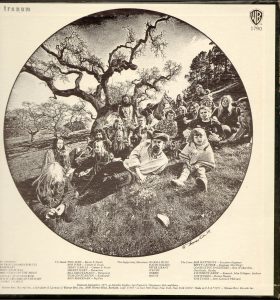
The curse seemed to have let up for a few years until the 1960s. By this time the property had exchanged hands several times and was then occupied by a hippie commune dubbing itself the Chosen Family. The “Family” were associated such local rock bands as the Grateful Dead, Jefferson Airplane and Quicksilver Messenger Service, among others, who performed at various parties at Olompali in the mid-‘60s. “Novato was completely comfortable, wide open, high as you wanted to get, run around naked if you wanted to…Everything was just super-groovy,” Garcia later said of their Olompali parties. (The back cover of the Dead’s Aoxomoxoa album features a photo of the band and various family members relaxing on a hill at Olompali.) Tragically, in 1969 two little girls, riding their trikes unattended, fell into the Olompali pool and drowned. Following an investigation into child welfare concerns, local authorities kicked the Chosen Family off the land. In 1977 a fire swept away the Burdell Mansion and destroyed several other structures, cleansing the property of its troubled history and putting to bed the final smoldering embers of the curse. The state took ownership of the property in the 1980s and established the grounds as a state park.
To get there, take the Atherton exit in Novato and following the signs to 8901 Redwood Blvd. Learn more at parks.ca.gov